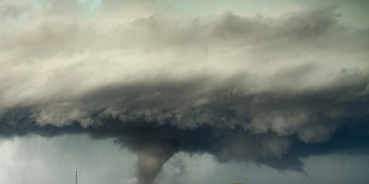
A dangerous severe weather outbreak is tearing through the Midwest and Great Lakes today, and the Chicago metro is sitting right in the bullseye. The National Weather Service has issued a Tornado Watch until 9 p.m. for northern Illinois and northwest Indiana, warning of strong tornadoes, large hail, and wind gusts up to 80 mph.
The Most Dangerous Hours Are Still Ahead
Meteorologists say the period between 4 p.m. and 8 p.m. today is when things could turn truly dangerous. A second line of storms moving in from Iowa is expected to bring strong tornadoes, damaging winds, and flash flooding across the entire Chicago area.
Why This Is Such a Big Deal
The Storm Prediction Center has placed most of the region under a Level 4 out of 5 severe weather risk — its second-highest alert level. Forecasters say there’s a 70% chance of a tornado within 50 miles of almost any location in eastern Iowa and northern/central Illinois.
Storms are expected to form individually before merging into one massive line capable of producing widespread wind damage with gusts of 70–75 mph or higher.
Two Rounds of Storms — and the Second One Is the Real Threat
The morning round of storms already knocked down trees and cut power to thousands. But forecasters warn the second round later today carries the main tornado, wind, and hail threat.
Strangely, brief sunny breaks between the two rounds are actually making things worse — that sunshine is adding fuel to the incoming storms, helping them grow stronger as they move east.
A Flash Flood Watch is in effect until 4 a.m. for Cook, DuPage, Will, DeKalb, Grundy, and Kendall counties, plus northwest Indiana. Rain could fall at 1 to 2 inches per hour, raising the risk of sudden flooding on roads.
Highways Are Already a Mess
Major routes including I-90, I-88, I-80, and I-55 are seeing standing water, downed trees, and debris. Drivers are being warned that just 12 inches of moving water can sweep a car off the road — and being in an SUV or truck doesn’t make you safe.
If a Tornado Warning is issued while you’re driving:
- Pull well off the road, away from trees and power lines, and get low
- Never shelter under an overpass — it actually speeds up the wind
Flights are also being impacted, with O’Hare seeing delays of nearly three hours and ground stops at both O’Hare and Midway.
5 Things to Do Before You Head Out
- Turn on Wireless Emergency Alerts on your phone
- Check weather.gov for live warnings in your county
- Plan your route around solid buildings, not overpasses
- If hail starts, pull under a gas station canopy or parking garage
- Never drive through standing water, even if it looks shallow
When Will It End?
The worst of the severe weather should clear the Chicago metro after 9 p.m. tonight, with calmer weather returning Friday. However, flooding and storm debris could still linger into Friday morning, so drivers should stay alert even after the watch expires.
Stay weather-aware, avoid unnecessary travel during the peak window, and have a plan ready if a warning is issued.